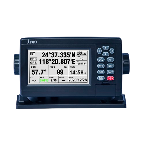
Description
GNSS chart plotter supports BDS, GPS dual-mode high-precision positioning, combined with self-developed SOG&COG filtering algorithm, it has advantages of stable SOG&COG, high receiving sensitivity, accurate position.
◆ 5 inch Color LCD with 480 x 272 resolution, wide angle of view.
◆ Classic& Utility dual operating system, you can switch freely.
◆ Built-in BDS, GPS dual-mode high-precision positioning module, the position information is stable and reliable.
◆ Support multi-language display, such as Chinese, English, Korean, etc.
◆ Many display pages can be chose and switched freely.
◆ Conform with the water proof standard of IP65, support counter mounting, flush mounting & ceiling mounting.
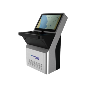
The Xinuo XF-520 is a compact, highly capable 5-inch GNSS chart plotter designed for marine navigation. It supports both BDS (Beidou) and GPS dual-mode high-precision positioning, delivering stable and accurate location data with the help of an optimized SOG & COG filtering algorithm. Its 5″ TFT color display has a resolution of 480 × 272, offering high brightness, a wide viewing angle, and clear readability under various lighting conditions.
The device runs on a dual operating system — “Classic” and “Utility” — allowing users to switch between interfaces depending on their preference or use case. It supports multiple display modes, including standard chart view, simple chart, GNSS data, AIS data, 3D navigation, and compass, giving navigators flexible ways to visualize map and sensor information.
Technical Specifications
| Display Unit | XF-520 | |
| Display Type | Color TFT LCD | |
| Size | 5 inch | |
| Resolution | 480 × 272 pixels | |
| Brightness | 400cd/㎡ | |
| Language | English, Simplified Chinese, Traditional Chinese, Vietnamese, Bahasa Malaysia, Turkish, Thai, Greek, Indonesian, Japanese, Korean, Spanish, Burmese, Persian | |
| Display Modes | Standard Chart View, Pure Chart View, Simple Chart View, AIS Data, Sailing Data, GNSS, 3D Navigation, Compass | |
| Memory Capacity | 50,000 waypoints, 50,000 markers, 500 routes, one route can indicate 200 waypoints , 1000 tracks, 1,600,000 track points | |
| Interface | 2 Ports NMEA0183 Output , 1 Ports NMEA0183 Input (Baud rate can be set indenpently) | |
| Power Supply | DC10V~36V | |
| Power Consumption | 4W or less (24V DC) | |
| Enviromental | ||
| Working Temperature | -15℃~+55℃ | |
| Storage Temperature | -20℃~+60℃ | |
| Waterproof | IP65 | |
Reviews
There are no reviews yet.