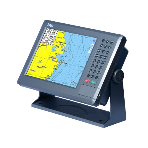
Description
GNSS chart plotter supports BDS, GPS dual-mode high-precision positioning, combined with self-developed SOG&COG filtering algorithm, it has advantages of stable SOG&COG, high receiving sensitivity, accurate position.
◆ Passed the EU CE certification.
◆ 10.4 inch color LCD with 800 x 600 resolution, wide angle of view.
◆ Classic& Utility dual operating system, you can switch freely.
◆ Built-in BDS, GPS dual-mode high-precision positioning module, the position information is stable and reliable.
◆ Support multi-language display, such as Chinese, English, Korean, etc.
◆ Many display pages can be chose and switched freely.
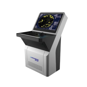
The XF-1069 is a robust and stylish 10.4-inch marine GNSS Chart Plotter designed for reliable navigation in coastal and fishing environments. It features a bright, high-resolution (800×600) color TFT LCD with multi-angle mounting options and unlimited backlight adjustment for comfortable use, day or night.
Pre-loaded with detailed Xinuo vector charts and fully compatible with C-MAP MAX, the XF-1069 supports fast chart rendering, real-time AIS target plotting, voice navigation, and extensive memory (6,000 waypoints, 200 routes). Multiple variants are available: base chart plotter, GF combo with 600 W dual-frequency fish finder, and B version with integrated Class B AIS transponder. Waterproof (IPX6/7), wide 10–36 V power input, and both bracket/flush-mount options make installation flexible on any vessel.
Technical specifications
| Display Unit | XF-1069 | |
| Display Type | Color TFT LCD | |
| Size | 10.4 inch | |
| Resolution | 800 × 600 pixels | |
| Brightness | 300cd/㎡ | |
| Language | English, Simplified Chinese, Traditional Chinese, Vietnamese, Bahasa Malaysia, Turkish, Thai, Greek, Indonesian, Japanese, Korean, Spanish, Burmese, Persian | |
| Display Modes | Standard Chart View, Pure Chart View, Simple Chart View, AIS Data, Sailing Data, GNSS, 3D Navigation, Compass | |
| Memory Capacity | 50,000 waypoints, 50,000 markers, 500 routes, one route can indicate 200 waypoints , 1000 tracks, 1,600,000 track points | |
| Interface | 2 Ports NMEA0183 Output , 2 Ports NMEA0183 Input (Baud rate can be set independently) | |
| WIFI | 802.11 b/g/n | |
| Power Supply | DC12V~36V | |
| Power Consumption | 10W or less (24V DC) | |
| Environmental | ||
| Working Temperature | -15℃~+55℃ | |
| Storage Temperature | -20℃~+60℃ | |
| Waterproof | IP65 | |
| GNSS | ||
| GNSS Receiver | 72 channels | |
| Receive Frequency | GPS L1: 1575.42MHz;BDS B1: 1561.098MHz | |
Reviews
There are no reviews yet.