
Description
The SC-500 GNSS Compass is a turnkey marine navigation solution, featuring a GNSS antenna, control/data box, and display unit, that delivers highly stable and precise heading, position, and vessel orientation data for boats, yachts, and work vessels.
SC-500 (III) GNSS satellite compass uses advanced satellite electronic navigation technology, which can provide high-precision positioning and heading data for marine navigation equipment, such as autopilots, echo sounder, radar, chart plotter, Class B AIS, etc. SC-500 (III) consists of antenna, data control box and display. Support stable heading data output and easy to operate.
Data Control Box
◆ 4 NMEA 0183 output, 2 AD-10 and 1 alarm data are able to connect to radar, autopilot, etc.
◆ LED displays real-time heading data.
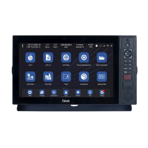
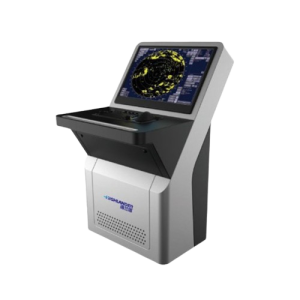
Display Unit
◆ 5 inch 480*272 resolution, wide viewing angle.
◆ 1 AD-10 data interface.
◆ Support table, embedded and ceiling installation.
◆ Support many display modes for freely selection and switching.
◆ Built-in global chart, enjoy regular update service.
GNSS Antenna
◆ The GNSS antenna can work independently, support 1 NMEA 0183 output.
◆ HDG output frequency is up to 20Hz.
◆ Follow the standards of ISO 22090-3, IEC 60945, IEC 62288, IEC 61162-1, IEC 61162-2.
Technical Specifications
| Display Unit | SC-500(III) | |
| Display Type | Color TFT LCD | |
| Size | 5 inch | |
| Resolution | 480 ×272 pixels (WVGA) | |
| Brightness | 400cd/㎡ | |
| Language | English, Simplified Chinese | |
| Display Modes | Compass, HDG, Heading, Rotation, Data page, Navigation | |
| Chart | XINUO-MAP | |
| Power Supply | DC18V~36V | |
| Power Consumption | 8W or less (24V DC) | |
| Environmental | ||
| Working Temperature | -30℃~+70℃ | |
| Storage Temperature | -40℃~+85℃ | |
| Waterproof | GNSS Compass Antenna, IP67. MKD, IP65. Data Control Box, IP42 | |
| GNSS Antenna | ||
| Receiver Frequency | BDS B1/B2; GPS L1/L2 | |
| GNSS Receiver | 432 channels | |
| Update Rate | Heading, up to 20Hz. Location, up to 20Hz | |
| Accuracy | Horizontal,1.5m (95%). Elevation, 2.5m (95%) | |
| Coordinate Systems | WGS84 (and others) | |
| Heading Accuracy | 0.2°rms | |
| Speed Accuracy | 0.03m/s rms | |
| Pitch accuracy | <1°rms | |
| Roll Accuracy | <1° rms | |
| Rate of Turn | Up to 90°/S | |
| Time to First Fix | Cold Start <25s, Hot Start <10s, Signal Re-acquisition <1s | |
| Compass Safe Distance | <0.6m | |
Reviews
There are no reviews yet.