Description
GNSS chart plotter supports BDS, GPS dual-mode high-precision positioning, combined with self-developed SOG&COG filtering algorithm, it has advantages of stable SOG & COG, high receiving sensitivity, accurate position.
◆ Passed the EU CE certification, China Classification Society CCS type approval.
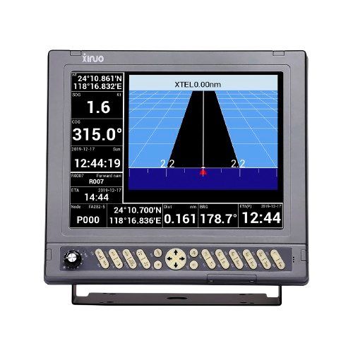
◆ 12.1 inch color LCD with 800 x 600 resolution, wide angle of view.
◆ Built-in BDS, GPS dual-mode high-precision positioning module, the position information is stable and reliable.
◆ Dual keyboards operation support, more convenient and efficient.
◆ Support multi-language display, such as Chinese, English, Korean, etc.
◆ Many display pages can be chose and switched freely.
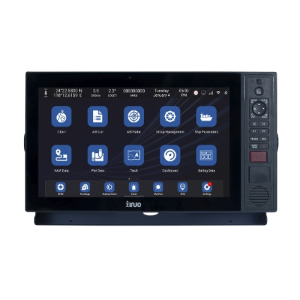
Navigation is streamlined by the plotter’s dual operating modes, “Classic” and “Utility,” allowing the user to switch between interfaces depending on preference or application. The HM-5812 supports multilingual displays (e.g., English, Chinese, Korean), making it globally accessible. Its intuitive interface supports various display modes, including standard chart, simplified chart, GNSS data, 3D navigation, sailing data, and compass views.
An intelligent voice system announces operational messages and alarms, enhancing situational awareness while underway. Software updates can be performed over a mobile network, ensuring that the unit stays current with the latest improvements. Built-in global reference charts come preloaded and can be upgraded periodically, so you can navigate with confidence.
Technical Specifications
| Display Unit | HM-5812 | |
| Display Type | Color TFT LCD | |
| Size | 12.1 inch | |
| Resolution | 800 × 600 pixels | |
| Brightness | 400cd/㎡ | |
| Language | English, Simplified Chinese, Traditional Chinese, Vietnamese, Bahasa Malaysia, Turkish, Thai, Greek, Indonesian, Japanese, Korean, Spanish, Burmese, Persian | |
| Display Modes | Standard Chart View, Pure Chart View, Simple Chart View, AIS Data, Sailing Data, GNSS, 3D Navigation, Compass | |
| Memory Capacity | 50,000 waypoints, 50,000 markers, 500 routes, one route can indicate 200 waypoints , 1000 tracks, 1,600,000 track points | |
| Interface | 3 Ports NMEA0183 Output , external GPS input, 1 Port AIS Input | |
| WIFI | 802.11 b/g/n | |
| Power Supply | DC12V~36V | |
| Power Consumption | 8W or less (24V DC) | |
| Enviromental | ||
| Working Temperature | -15℃~+55℃ | |
| Storage Temperature | -20℃~+60℃ | |
| Waterproof | IP65 | |

Reviews
There are no reviews yet.