Description
GNSS chart plotter supports BDS, GPS dual-mode high-precision positioning, combined with self-developed SOG &C OG filtering algorithm, it has advantages of stable SOG & COG, high receiving sensitivity, accurate position.
◆ Passed the EU CE certification, China Classification Society CCS type approval.
◆ Built-in BDS, GPS dual-mode high-precision positioning module, the position information is stable and reliable.
◆ Support multi-language display, such as Chinese, English, Korean, etc.
◆ Many display pages can be chose and switched freely.
◆ Connect to mobile network to upgrade software online.
◆ Install in intelligent voice to broadcast operation content, alarm content, etc.
◆ Classic & Utility dual operating system, you can switch freely.
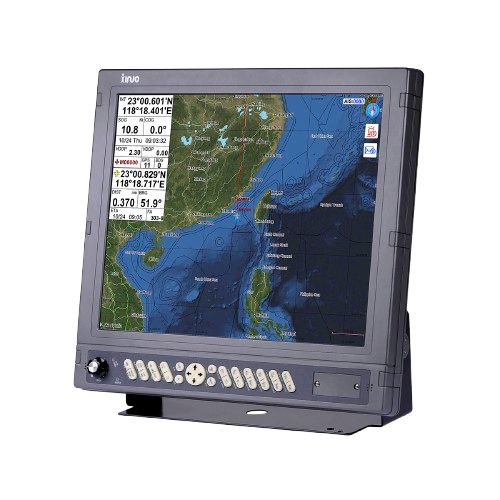
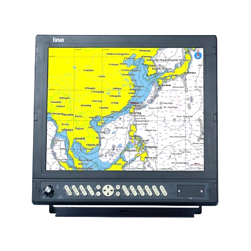
The Xinuo HM-1817 17″ GNSS Chart Plotter is a professional-grade marine navigation system that offers high-precision positioning through built-in GPS and BDS dual-mode GNSS. Featuring a large 17-inch display with 800×600 resolution, it supports C-MAP MAX charts and provides flexible chart viewing. The device includes dedicated keys for marks, waypoints, routes, and tracks via a wired remote, making navigation straightforward even in challenging conditions. With a memory capable of storing 10,000 waypoints, 10,000 markers, and 200 routes, the HM-1817 is ideal for commercial and recreational vessels. It offers IPX6 waterproofing, multiple NMEA 0183 ports, SD-card data saving, voice alerts, dual operating modes (Classic and Utility), and online software updates through a mobile network.
Technical Specifications
| Display Unit | HM-1817 | |
| Display Type | Colour TFT LCD | |
| Size | 17 inch | |
| Resolution | 1280 × 1024 pixels | |
| Brightness | 500cd/㎡ | |
| Language | English, Simplified Chinese, Traditional Chinese, Vietnamese, Bahasa Malaysia, Turkish, Thai, Greek, Indonesian, Japanese, Korean, Spanish, Burmese, Persian | |
| Display Modes | Standard Chart View, Pure Chart View, Simple Chart View, AIS Data, Sailing Data, GNSS, 3D Navigation, Compass | |
| Memory Capacity | 50,000 waypoints, 50,000 markers, 500 routes, one route can indicate 200 waypoints , 1000 tracks, 1,600,000 track points | |
| Interface | 3 Ports NMEA0183 Output , 3 Ports NMEA0183 Input (Baud rate can be set independently) | |
| WIFI | 802.11 b/g/n | |
| Power Supply | DC12V~36V | |
| Power Consumption | 15W or less (24V DC) | |
| Environmental | ||
| Working Temperature | -15℃~+55℃ | |
| Storage Temperature | -20℃~+60℃ | |
| Waterproof | IP65 | |
Reviews
There are no reviews yet.